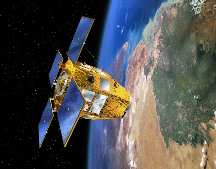
French CSO-3 spy satellite. Credit: Cnes, D. Ducros.
By Oleksandr Arhat,
Published by Militarnyi, 19 January 2026
Two-thirds of the intelligence Ukraine receives today comes from France, whereas a year ago it relied mainly on the United States. French President Emmanuel Macron said this on January 15, 2026, during a speech to military personnel.
For France, this is not just a statistic showing its contribution to Ukraine’s support. It is presented as evidence that the principle of “strategic defense autonomy,” pursued since the time of President Charles de Gaulle, is working.
With this statement, Macron signaled that the United States is no longer the sole pillar of Europe’s security – at least in the intelligence domain. This, in turn, suggests that Ukraine cannot be rendered “blind” or “deaf” as long as European support continues.
But do France’s actual capabilities truly justify such a conclusion?
France’s commitment to ensuring that Ukraine is not deprived of space-based and signals intelligence was made clear as early as March 2025 by French Minister of the Armed Forces Sébastien Lecornu:
France is an autonomous power. We will not leave Ukraine blind on the battlefield. Wherever the American flow [of intelligence] stops, the French flow will immediately take over. Our satellites and electromagnetic intelligence assets now serve Europe’s security and therefore Ukraine’s as well.
France does, in fact, possess highly advanced capabilities for collecting valuable intelligence. These capabilities have been built up systematically over decades. The war in Ukraine has become a real-world test, demonstrating that they can deliver strategic advantages against an adversary on the scale of Russia.
The CSO Military Satellite Constellation (Composante Spatiale Optique)
In 2025, France completed the deployment of its three-satellite CSO (Composante Spatiale Optique) military constellation. Notably, a Ukrainian An-124 aircraft transported the third satellite, CSO-3, to the launch site. The first two satellites, launched in 2018 and 2020, were placed into orbit by Russian Soyuz-ST-A rockets.
The satellites were built by Airbus Defence and Space, while the optical systems – lenses and sensors – were provided by Thales Alenia Space.
All three satellites share an identical design. Their optical systems are based on the Korsch telescope configuration. The mirrors are made from ultra-stable Zerodur glass-ceramic, which has an almost zero thermal expansion coefficient. The CSO satellites also feature an infrared imaging channel. Their telescopes can capture multiple images of the same target from different angles at the same time, enabling the creation of detailed 3D digital terrain models.
The three CSO satellites each play a distinct role in the intelligence collection process.
CSO-1 operates at an altitude of 800 km and is tasked with wide-area reconnaissance. It images large regions at a resolution of up to 35 cm, which is sufficient to detect armored vehicles or aircraft at major facilities.
CSO-2 flies at a lower altitude of 480 km, allowing it to capture images with a resolution of up to 18 cm per pixel. Its primary role is identification. At this level of detail, analysts can distinguish between a T-72 and a T-90 tank by the layout of reactive armor on the turret, and high-quality imagery also makes it possible to detect decoys. CSO-2 operates in a layer of orbit where traces of Earth’s atmosphere are still present. The satellite is exposed to rarefied air, including atomic oxygen, which creates a harsh operating environment. To compensate for orbital drag, it must regularly use its thrusters. As a result, CSO-2’s operational lifespan is limited to about 10 years, until 2030.
CSO-3 has the same technical characteristics as CSO-1, but a different mission. Its role is to increase the revisit rate – the frequency with which the same area can be imaged. CSO-3 operates on the same orbit as CSO-1 but at a different orbital phase, allowing more frequent coverage of key locations.
For Ukraine, this means guaranteed daily access to imagery of any area in the occupied territories or within Russia itself. Before the launch of CSO-3, “blind gaps” between satellite passes could last several days. Now, by using the satellites’ camera maneuverability, intelligence services receive at least one and often several images per day, allowing event dynamics to be tracked almost in real time.
France is the sole owner and operator of the CSO constellation. However, it shares access to the imagery with several countries. Germany and Italy receive optical images through barter arrangements, exchanging them for imagery from their SAR (Synthetic Aperture Radar) satellites. Sweden gains access in return for providing the Kiruna ground reception station located north of the Arctic Circle. Belgium participated in the project as a co-investor.
All CSO imagery is automatically classified at the highest level of secrecy.

Commercial Solutions: Pléiades/Pléiades Neo
From 2011 to 2021, Airbus Defence and Space deployed four commercial Earth observation optical satellites.
In 2011–2012, the Pléiades-1A and Pléiades-1B satellites were launched into a 694 km orbit. These satellites have a resolution of up to 50 cm per pixel and capture imagery with a swath width of up to 20 km. Both satellites are positioned 180 degrees apart in orbit.
In 2021, the second-generation Pléiades Neo 3 and Pléiades Neo 4 satellites began operations at an altitude of 620 km. Ukraine contributed to the practical deployment of this constellation. These satellites were launched by a Vega rocket, whose fourth stage was powered by a Ukrainian RD-843 engine, manufactured in Dnipro at the “Pivdenmash” facility. This stage provided the “final mile” and precise satellite separation in orbit.

Unfortunately, the Vega-C mission (VV22) carrying the Pléiades Neo 5 and Pléiades Neo 6 satellites in December 2022 failed shortly after launch. The cause was an anomaly in the Italian-made Zefiro-40 second stage.
The Pléiades Neo satellites have a resolution of up to 30 cm per pixel, and a single image covers a swath of about 14 km.
Communication with the satellites is carried out through the SpaceDataHighway system – a laser data link to relay satellites positioned in geostationary orbit at approximately 36,000 km altitude. From there, the signal is transmitted down to Earth. This allows imaging tasks to be programmed less than an hour before the satellite passes over a target area, and the captured images can reach the ground within minutes. In this way, intelligence can be obtained almost in real time.
Although this constellation is a commercial project, the French Ministry of Armed Forces is its priority user.
It can be assumed that French assistance in space intelligence combines the provision of classified imagery from the CSO constellation with “commercial” Pléiades images. In terms of resolution, Pléiades Neo imagery is operationally comparable to data from CSO-1 and CSO-3, while the process of transmitting it is significantly simpler.

Sydney Airport, Australia. Pléiades Neo image with 30 cm/pixel resolution
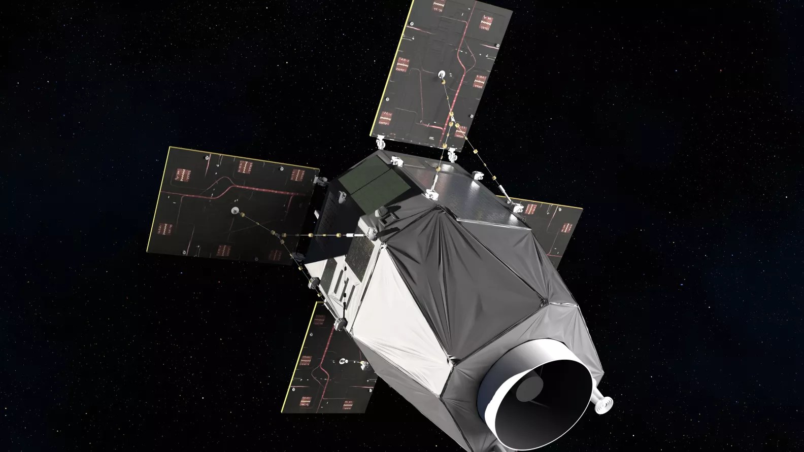
SIGINT Satellites: CERES
On November 16, 2021, just a few months before Russia’s full-scale invasion of Ukraine, France added a new component to its space intelligence capabilities. A European Vega launch vehicle, equipped with a Ukrainian RD-843 fourth stage, placed the CERES satellite constellation (Capacité de Renseignement Électromagnétique Spatiale) into orbit. This marked the first fully operational orbital SIGINT system in Europe.
The constellation consists of three satellites. Little information is publicly available about their technical specifications. The CERES satellites are built on the EliteBus platform—a versatile satellite bus that Airbus also developed for networks like Globalstar-2. The EliteBus platform weighs between 400–700 kg, is equipped with four thrusters for orbital adjustments, and has solar panels generating about 1.5 kW of power. The satellites themselves were manufactured by Airbus Defence and Space, while the sensor module with highly sensitive antennas was provided by Thales Alenia Space.
The three CERES satellites orbit at an altitude of approximately 700 km and maintain a stable triangular formation. This configuration allows them to locate sources of radio emissions on Earth using triangulation. The system calculates the differences in signal arrival times at each satellite, as well as the phase differences of the frequencies detected by the receivers. Using this data, it solves a trigonometric problem to geolocate the emission source from orbit with high accuracy.

Visualization of the CERES SIGINT Satellite Group
The CERES satellites can detect enemy air defense positions when their active radars are operating. By analyzing the signals, they can also identify the types of radar systems. They have similar capabilities for electronic warfare equipment. In general, the stronger the signal, the more accurately its location can be determined.
The satellites can also monitor communications transmitters, helping to estimate the locations of command posts and headquarters.
Explaining the unique capabilities of CERES in 2021, French Minister of Armed Forces Florence Parly said:
“We will no longer rely on partners to know where a threat comes from. In space, as on Earth, the principle is the same: those who cannot see or hear – cannot decide. CERES is a tool that gives us freedom in decision-making.”
Which Space-Based Data Can France Not Provide to Ukraine?
If we accept that two-thirds of intelligence data comes from France, where does the rest come from, and is it exclusive? Which space capabilities are currently unavailable to France or Europe as a whole?
Unfortunately, Europe is completely “blind” when it comes to early warning of missile attacks. No European country can detect ballistic missile launches from space. In contrast, the United States operates the SBIRS (Space-Based Infrared System). Satellites in geostationary orbit (36,000 km) monitor the Earth in the infrared spectrum. This system detects the heat flashes from rocket engines (such as Iskander or Oreshnik missiles) and jet aircraft (for example, a MiG-31K taking off from Savasleyka). Its computing system then predicts the trajectory of potential strikes.

Architecture of the U.S. Missile Early Warning System (SBIRS)
France’s space-based SIGINT capabilities are limited. CERES satellites can detect sources of electromagnetic emissions only when they pass directly over an area of interest. In contrast, the U.S. Orion system has geostationary satellites that continuously monitor the entire Earth.
France does not operate its own radar (SAR) satellites. Instead, it receives SAR imagery from Germany and Italy through barter agreements. Neither country publicly confirms this, but multiple indirect sources including media reports citing insiders and parliamentary committee findings suggest that both countries provide space intelligence data to Ukraine.
Canada previously funded services from MDA, the operator of RADARSAT-2 radar satellites, though this agreement has now expired. Ukrainian forces also have access to SAR imagery via the Finnish company ICEYE, which has Polish origins.

Image of Gdańsk from the Polish ICEYE satellite, December 6, 2025. Photo: Władysław Kosiniak-Kamysz
How dependent is Ukraine on U.S. space intelligence? According to the French president, less than one-third. However, according to former head of military intelligence Kyrylo Budanov, the dependence is still critical. Beyond the intelligence provided as assistance, Ukraine also receives a large number of satellite images from the U.S. on a paid basis:
If we exclude the images provided as assistance: optical imagery drops by about 15–17%, and radar imagery by around 46%. This is difficult, but not critical. It becomes critical if a political decision is made to block contracts – then we fall almost to zero.
The Ukrainian situation is a reminder for every European country of the importance of reliable sources of space intelligence. Clearly, achieving full national strategic autonomy in this domain is both unrealistic and impractical due to the cost. European cooperation, however, offers a real opportunity to achieve parity with both the block of authoritarian states led by China and allies across the Atlantic.
See: Original Article


